Resources are available to teachers to use freely in the course of their work, but they should not be reproduced or published beyond the parameters of internal school projects without the express permission of the institution at which the original is held. These notes accompany the images. The questions in italics are intended to challenge ideas and to prompt further research.
Why build a canal to connect Stroud with the River Severn?
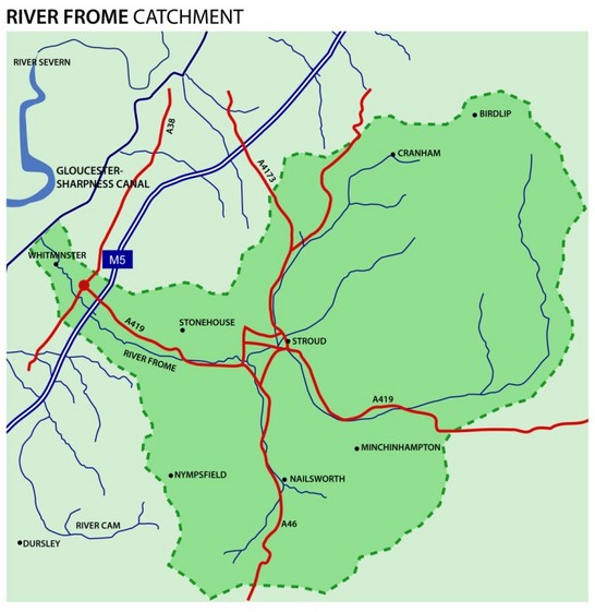

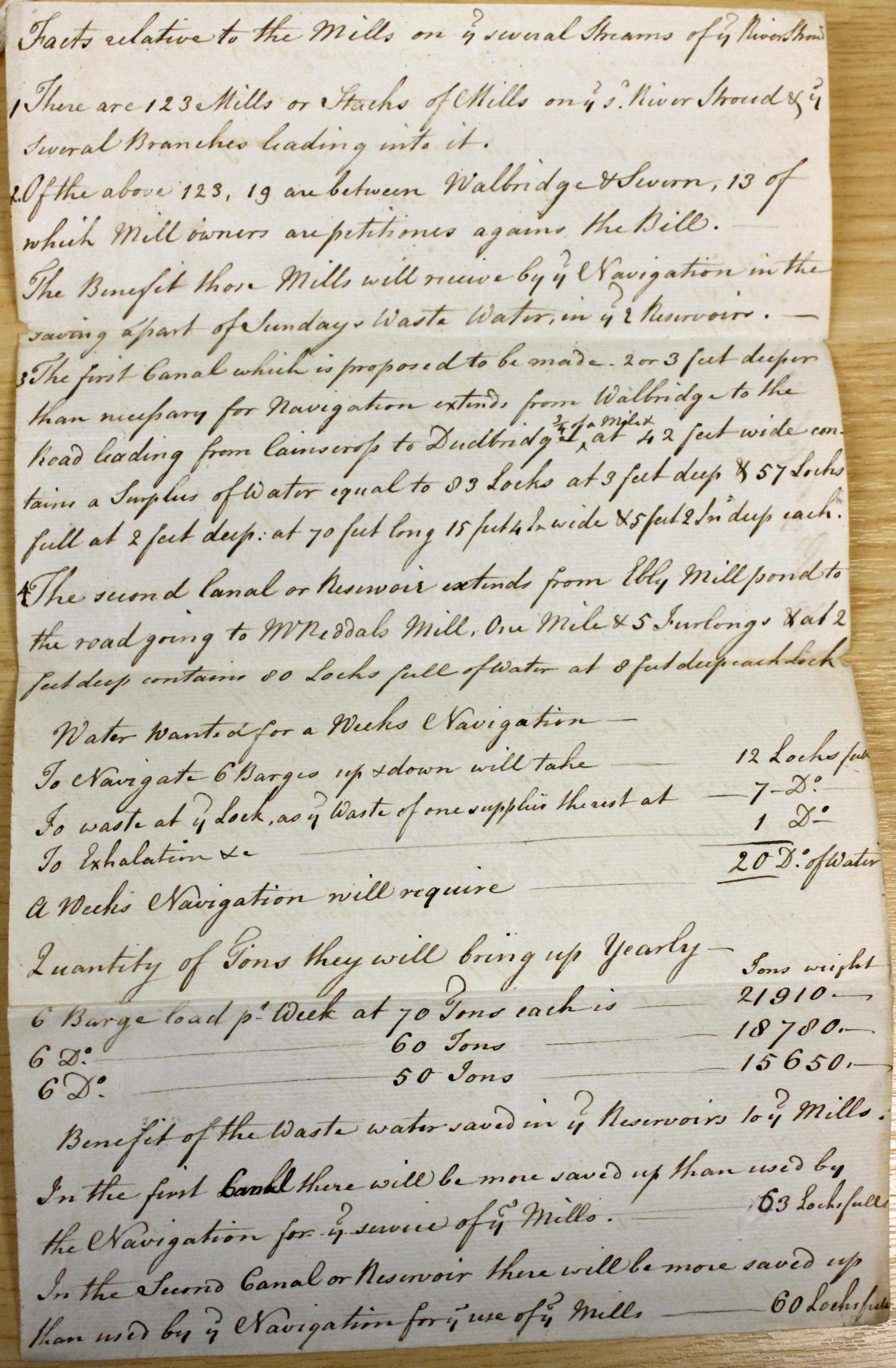
Why was the building of the canal opposed so strongly?
The building of the canal was opposed by mill owners especially those who were reliant on the slower waters of the lower River Frome. William Dallaway, however, was very eager for the canal to be built to lower heating costs for ordinary people and for businesses.
Who was involved in building the canal?
Images 17 to 20 show tenders written by craftsmen for the work:
Image 17 is "A Proposal for Compleating the Cutting &c from Chippenham Splat to Walbridge" from Robert Perry.
Image 18 contains "Proposals for Erecting & Building a Bridge over the Stroudwater Navigation in the Bristol Road" from John Couch.
Image 19 is "An Estimate for the Expence of Building the five Locks two Swivle Bridges and one Brick Bridg".
Image 20 is "A Calculation of the Expence of Building a 9 feet Lock with Bricks".
Benjamin Grazebrook and the Grazebrook family were the moving forces in building and running the canal up until the early 1800’s. There are no pictures that survive of them but Fiona Eadie’s stories capture them well.
Benjamin Grazebrook built Rowcroft in Stroud and Joseph Grazebrook formed the first bank in Stroud.
Many people were engaged to build the canal . They tended to be local craftsmen but the cutters were often from further away and used empty cottages and sheds in which to live. If these premises were not available then they made camps.
Bricks were generally made by the side of the canal but Frampton on Severn had it’s own family of brick makers who were able to use the parts of the canal that were already cut and in water to transport bricks to where the work was going on.
The canal was lined by puddling clay. Puddling was not a popular job because it involved squashing the wet clay under workers boots which became very heavy. Rampering involved driving cattle or sheep along the cut banks to ensure they were tamped down and strong.
The canal was opened on Wednesday 21st July 1779. Image 21 is a handwritten report of the opening, while Image 22 shows how the opening was reported in the Gloucester Journal.
How was the canal used during it’s working life?
Images 25 to 37 illustrate how the canal worked/
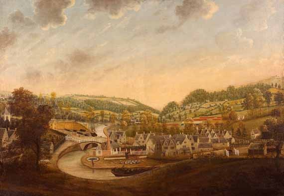
In the early days, vessels were towed along the canal by men. Image 25 shows two men hauling a barge past Whitminster House and Image 26 shows three men towing past Stonehouse church. The ornamental barge in the latter picture appears to come from the artist’s imagination.
The painting in Image 27 shows a barge being pulled past Ebley Mill but fails to show the mules pulling the boat. The painting in Image 29 shows men hauling a loaded barge towards Brimscombe Port, but also suggests that Trows sailed up the canal, a practice forbidden by the bye laws. Both paintings are in the Museum in the Park in Stroud.
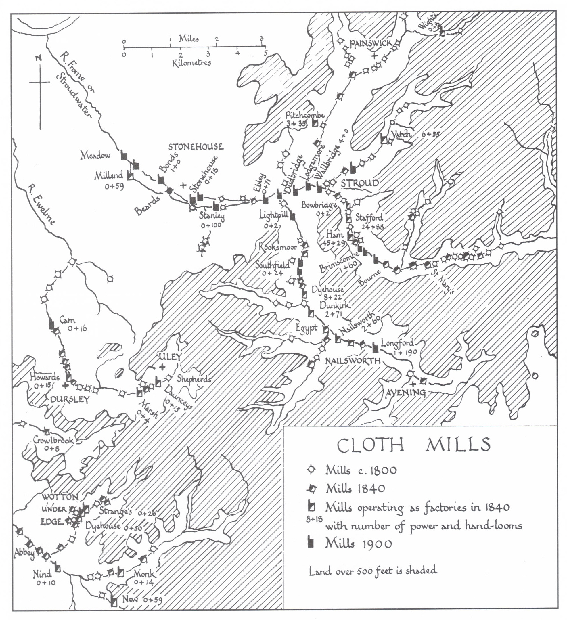
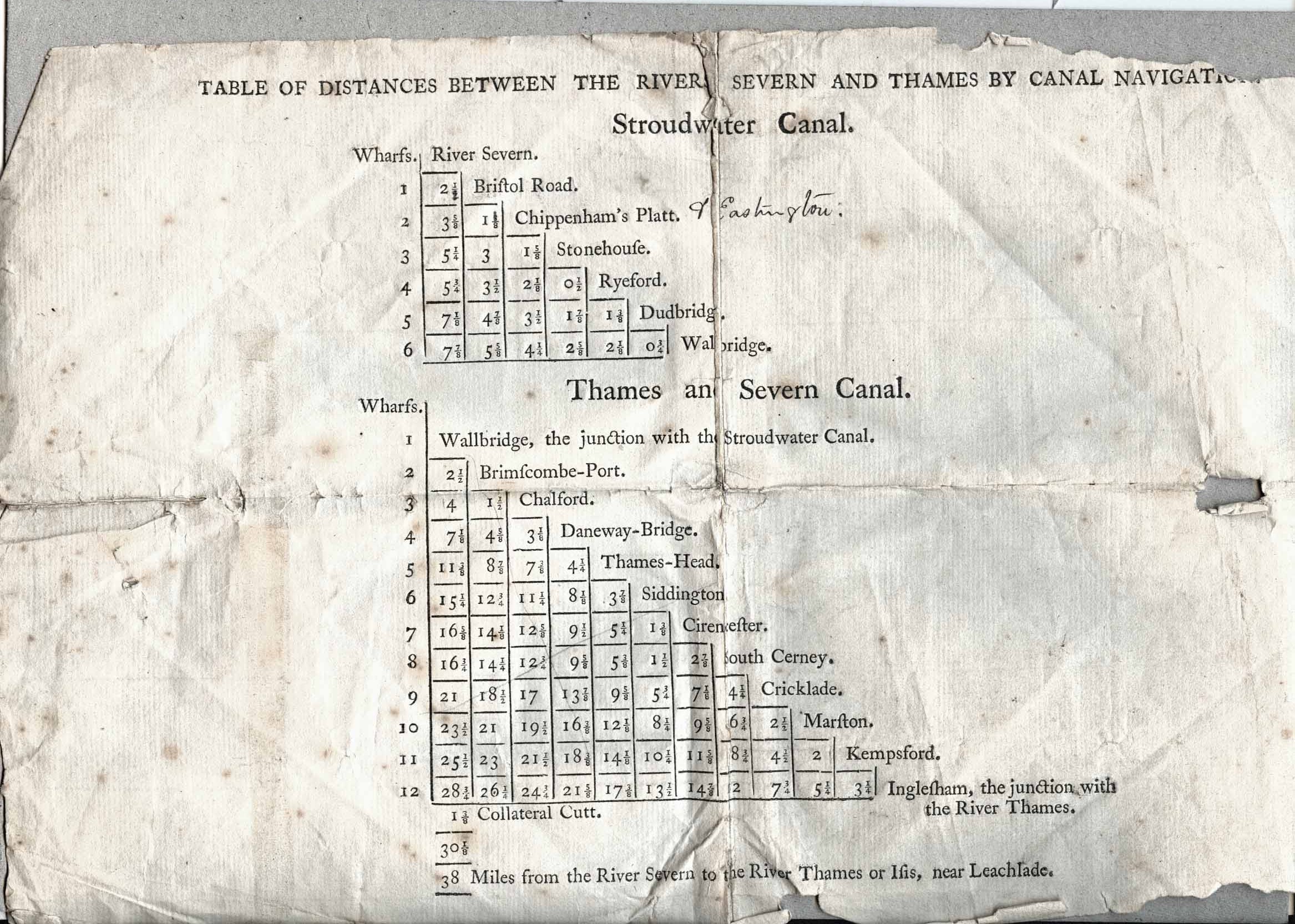
Many bye laws were created to ensure that the infrastructure of the canal wasn’t damaged and also to ensure that the wharfingers on the canal didn’t defraud the Company of proprietors of the Stroudwater Navigation. Image 34 and Image 35 show the Bye Laws that were in force being amended to meet changing practices. Image 54 shows the wharfs that developed along both the Stroudwater and Thames and Severn canals. Showing mileages was important because the Company of Proprietors charged boat masters per mile for using the canal.
Trading developed over the decades and the types of cargo transported by the boats is shown in the tonnage books (Image 36) and list of vessels passing in and out of the River Severn (Image 37). Image 39 show that the tonnage rates on canals, such as the Gloucester & Berkeley Canal, which traded internationally could be quite complicated.
Coal was brought from as far away as Tenby as well as the Forest of Dean. Stone was brought from the Forest of Dean and from near Bristol. The goods could be sent over a wide range of connected canals, as shown in Image 42.
The tokens shown in Image 31/Image 32, and in Image 33 were in general circulation for a brief period in response to a national shortage of small coins. They were issued by businessmen who chose images they thought would engender confidence in the use of the token as money.
The trow Reliance shown in Image 46 was well known for regularly bringing coal from Newport to Stroud gas works for many years.
Trows and barges based on the Stroudwater Canal traded around the Bristol Channel (Image 43), but as they had open holds they were normally confined to the relatively sheltered waters east of the islands of Steepholm and Flatholm.
Image 52 Boat building and boat repair went on all along the Stroudwater Canal. This boat is being launched at Saul Junction boatyard which still exists, but boats were built at Eastington and Chipman’s Platt.
How did changes to the region affect the canal?
In 1789 the Thames and Severn canal was opened with the purpose of joining the R. Severn and the R. Thames. It runs from Lower Lock at Wallbridge to Lechlade where it joins with the R. Thames. At one time Sapperton Tunnel (Image 30) was one of the longest in Britain. The building of the canal led to the creation of Brimscombe Port as a transhipment port because Severn Trows could not go beyond the port as they were too big.
In Image 29 the coal island at the port can be seen and the type of boat used to carry cargo can also be seen. The island was used to store coal to prevent stealing. The very grand Thames & Severn Canal company building can be seen in the background. This image can be viewed at the Museum in the Park.
Gloucester & Berkeley Canal Company
In 1820 the Gloucester & Berkeley Canal Company cut through the Stroudwater canal to form Saul Junction (Image 38 and Image 40). This enabled boats to move from the R. Severn at Sharpness up to Saul Junction avoiding the treacherous sand banks of the river. Boats could then go either onto Gloucester or to Stroud. (It is now called the Gloucester & Sharpness canal because the Company ran out of money before getting to Berkeley Pill.) The tolls charged on the Gloucester & Berkeley canal shown in Image 39 deterred many boat masters from using it. Many boats were lost on the river.
In the basin at Saul Junction (Image 41) large vessels could discharge cargoes into smaller vessels that could carry the goods up the Stroudwater Canal.
1845 saw Isambard Kingdom Brunel opened the Great Western railway line from London to Gloucester through Swindon and Stroud . The viaduct at Capel’s Mill (Image 45) was designed by him and was originally a wooden construction. When this line was connected to the South Wales railway (Image 44) traffic from Wales to London was routed through Gloucester until the Severn Tunnel was built.
The Two World Wars. 1914-1918 and 1939-1945
During the First World War, so many men were being called up to fight that keeping the canal clear of reeds was an impossible task despite the then government asking all canals to carry heavy loads so leaving railways to carry people. The Stroudwater didn’t recover and by the time the Second World War was being waged the canal was in desperate repair and very neglected except for Saul Junction where boats intended for rescuing airmen who had parachuted out of planes over the Severn Estuary were stored along the Stroudwater stretch of the Junction.
The canal was abandoned in 1954 and between that time and now motor ways have replaced water transport.
The restoration of the Stroudwater Canal started in 1972 with the formation of the Cotswold Canals Trust and continues today with the support of £23.5 million and involve 700,000 hours of volunteer time.
The next phase of physical restoration will be to restore from Stonehouse to Saul Junction by 2023. But more importantly this major project hopes to help build inclusive communities that work together to not only develop business and opportunities for people but to conserve, protect and enhance wildlife.
The following images may also be of relevance to your teaching: