Hugh Conway-Jones explains how the Stroudwater Company arranged for their canal to draw water from the River Frome despite initial objections from local mill owners.
In the eighteenth century, the woollen cloth industry in the Stroud Valley was thriving, but a cheaper source of coal was needed to heat the water used for fulling and dyeing woven cloth. This need inspired a group of promoters to seek an Act of Parliament in 1730 to authorise making the River Frome navigable between Framilode and Stroud.
The project was generally well-supported, but it attracted significant opposition from the mill owners on the river itself, who feared that the water needed to operate the locks would reduce the amount available to manage their own mills. The promoters obtained their Act, authorising a lock in a bypass channel around each of the 14 mills, but they lacked the resources to implement it, and they abandoned the project.
Forty years later, a new generation of promoters came up with a new way of using the powers of the 1730 Act. They established a company in 1774 to construct a waterway by linking two short sections of the River Frome and one tributary stream with long artificial cuts and a few locks. Contact with the river at the three points was necessary so that water could be drawn to replace the water lost when boats passed through the locks. This combination of natural river with artificial cuts was known as a navigation, and the promoter's company was the Company of Proprietors of the Stroudwater Navigation.
Construction work started at Framilode, but the mill owners on the Frome challenged the new proposal, fearing loss of 'their' water. In 1775, they instigated a case at Gloucester Assizes to test the legality of using the 1730 Act for a somewhat different purpose. This court ruled that the Company only had the right to make the river itself navigable, with a few short cuts, but not to dig long new cuts independent of the river.
The Company then undertook a programme of lobbying and experimentation in preparation for seeking its own Act. In particular, the Company collected information showing that the amount of water that ran to waste on Sundays, when the mills were not working, was more than enough to work the locks during the following week. All that was needed was careful management of the water. The promoters were so sure of this that they accepted a clause in their bill before Parliament, promising to pay a stipulated fine if taking water for the canal ever interfered with the operation of a mill. This commitment was sufficient to secure the approval of a new Act in 1776.
Construction work resumed at Framilode, and the section to the Bristol Road was opened to commercial traffic in 1778, including a length of river at Whitminster. However, this experience showed that the river deposited so much silt in the still water of the adjoining cut that it interfered with the use of the lock there. So the Company changed their plans for the other two contact points with the river. At Ebley and Lodgemore, the river and the tributary were diverted through a culvert under the canal, and weirs were installed to provide the required water supply when the river was high.
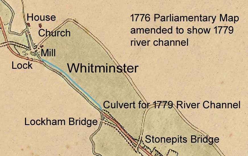
Soon after the entire canal opened, the same modification was made at Whitminster: the Company bought a strip of land and dug a new channel for the river with a culvert under the original line (shown blue on the map). The result was that the waterway became completely independent of the river and could properly be called a canal. The culverts were commonly called aqueducts, but that word now has a grander connotation.
Since then, the waterway has usually been referred to as a ‘canal’, but over the years, a significant minority have continued to use the term ‘navigation’, presumably because that word is in the Company's name. After the canal was formally closed in 1954, its channel between the culvert and the lock at Whitminster was filled in as part of a flood alleviation scheme, and the current restoration project is planning to make use of the adjoining 1779 river channel over that length.
Postscript. The promoter's confidence that there would be sufficient water in the river, both for the mills and for the canal, was well justified. The Company's archive contains only a few references to difficulties caused by taking water from the river during working hours (primarily associated with supplying water to the Gloucester & Berkeley Canal), and there were only two occasions when the Company had to pay the stipulated fine.
1730 Act, D1180/5/5.
Objections to 1730 Act, D1180/5/1.
Company formed in 1774, D1180/1/1.
Case at Gloucester Assizes, GJ 7 Aug 1775.
New Act 1776 including promise to pay a fine, D1180/5/5.
Canal open to Bristol Road 1776, D1180/4/1.
River contacts on the level replaced by culverts & weirs, D1180/6/11.
Buying land and constructing the 1779 river route, D1180/1/1 p268-293.
Fine for disturbing mill operation paid twice in 1820, D1180/9/2 p21.